Maps
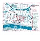
Various maps of St. Paul
I will be building custom maps in the very near future, in the mean time I am posting pre-made maps so you might get a lay of the land for downtown St. Paul.
Don’t let the maps fool you dimension-wise, The longest walk between any two points, for anything I have planned for NPS 2010 is 20 minutes. That includes hotels, venues, restaurants, and events. and it is unlikely someone would to have to traverse that distance for anything during their stay here. Most destinations can be reached in a 2 to 10 minute walk.
Parking in St. Paul is very inexpensive, but look around or know where you want to park first. Some ramps and lots can be much more expensive than another right next to it.
Some ramps charge as much as $17 a day, others as little as $1.50 (and a short walk) with in and out privileges.
Some of the potential host hotels I am speaking with offer free parking with a room. Others charge approximately $15 per day with in and out privileges. These details will be banged out during more formal negotiations.
I do recommend parking in a pay lot. Parking meters are mostly set at 25 cents for 9 minutes. It adds up fast. Most meters don’t need to be fed after 4:30 or 6:00pm, but be careful – You can only park on certain streets on certain nights after 2:30am, and it changes from day to day – watch the signs closely.
The good news is, a parking ticket in downtown St. Paul is only $30.
Transportation overview
Virtually all of the major buildings in downtown St. Paul are connected by ‘Skyways’. Over 6 miles of second floor walkways that cut through buildings and over streets - so you never have to go outside. Very handy in the winter, but it’s so nice in August; you should have no need for them. That said, the skyway system is a city within the city, filled with shops, restaurants and more. Check it out.
Skyway map
This is just a preliminary map of some of the downtown restaurants.
We are currently putting together a map and catalog of all the local restaurants, diners, coffee shops, bars, and fast(er) food establishments. This will include information on location, atmosphere, price range, and specialty options like vegetarian meals.
Restaurant map
If you don’t want to walk, take the bus. There is only one bus you will have to know to get around for Nats in ’09. The #21 runs all the way through downtown in a straight line. It heads south on 5th street and comes back on 6th street – both are one way streets, so it won’t be hard to figure out where to catch the bus and which way to go.
Buses cost only 50 cents per trip in the downtown zone. 6 hour, day, or monthly passes can also be purchased, but this shouldn’t matter, as I am trying to work out a deal with Metro Transit so busses won’t cost a thing for anyone with a festival pass.


